The Olympic Peninsula: A Living Record of Tectonic Force and Ecological Resilience in the Pacific Northwest

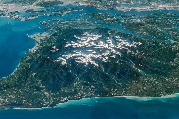
Situated at the extreme northwestern edge of the contiguous United States, the Olympic Peninsula stands as a profound testament to the dynamic forces that shape the Earth’s surface. Captured in a striking composite image by an astronaut aboard the International Space Station, the region reveals a complex tapestry of snow-capped peaks, ancient temperate rainforests, and intricate river systems that drain into the surrounding saline waters. This perspective, taken from an altitude of approximately 250 miles, offers more than just a scenic vista; it provides a visual inventory of a wilderness bastion that is currently navigating the dual pressures of tectonic uplift and rapid climatic change.
A Tectonic Legacy: The Geological Formation of the Olympic Mountains
The rugged interior of the peninsula is dominated by the Olympic Mountains, a range whose origins are rooted deep beneath the Pacific Ocean. Geologically, the Olympics are an "accretionary wedge," formed through the violent and slow-motion collision of tectonic plates. Between 55 and 15 million years ago, the Juan de Fuca plate—a dense oceanic plate—began its descent beneath the more buoyant North American plate in a process known as subduction.
As the oceanic plate slid downward, vast quantities of marine basalt from undersea volcanic eruptions, along with thick layers of sand and mud deposited by ancient rivers, were literally scraped off the ocean floor. This material did not descend into the mantle; instead, it crumpled, folded, and piled up against the edge of the continent. Over millions of years, these marine sediments were compressed into rock and thrust skyward, eventually reaching elevations of nearly 8,000 feet (2,440 meters).
Today, this tectonic engine remains active. The Cascadia Subduction Zone continues to push the mountains upward, yet the range does not grow indefinitely. The Olympic Peninsula is one of the wettest places in North America, receiving upwards of 140 inches of precipitation annually in its western valleys. This immense volume of water, falling as snow at high elevations and rain in the lowlands, creates a powerful erosive force. Glaciers and rivers carve into the rising rock as quickly as it is pushed up, resulting in a state of topographic equilibrium where uplift and erosion essentially cancel each other out.
The Glacial Crisis: Retreating Ice in a Warming Climate
The "Image of the Day" highlights the snow-capped summits that feed the peninsula’s extensive glacial systems. However, data from the National Park Service and independent glaciologists indicate that these icy mantles are in a period of significant decline. Glaciers are critical to the peninsula’s hydrology, acting as frozen reservoirs that release cold water during the dry summer months, which is essential for the survival of native salmon species.
A comprehensive study conducted in 2015 tallied 255 glaciers and perennial snowfields across the Olympic Range. The findings were stark: in the 35 years preceding the study, 35 glaciers and 16 perennial snowfields had completely vanished. The remaining glaciers, such as the Blue Glacier on Mount Olympus, are thinning and retreating at an accelerated pace.
Environmental scientists suggest that the loss of these glaciers represents a fundamental shift in the regional ecosystem. As the "cool storage" of the mountains diminishes, summer stream temperatures are expected to rise, and flow volumes are expected to drop. This creates a cascading effect on the biodiversity of the Olympic National Park, particularly for the cold-water-dependent trout and salmon that have defined the region’s ecology for millennia.
Rivers of Life: The Elwha Restoration and the Temperate Rainforests
Radiating outward from the central peaks are the deep river valleys that define the peninsula’s western and northern slopes. The Hoh, Queets, and Quinault rivers flow westward toward the Pacific, carving through some of the world’s last remaining temperate rainforests. These valleys are home to massive Sitka spruces and Western hemlocks, draped in clubmoss and ferns. The Hoh River Valley, in particular, is recognized for its "One Square Inch of Silence," a project dedicated to preserving the area as one of the most naturally quiet places in the United States, free from human-caused noise pollution.
To the north, the Elwha River tells a story of human intervention and subsequent ecological redemption. In the early 20th century, two dams—the Elwha Dam and the Glines Canyon Dam—were constructed to provide hydroelectric power for the burgeoning pulp and paper industry in Port Angeles. While they fueled economic growth, they also decimated the river’s salmon runs, blocking fish from reaching more than 70 miles of pristine spawning habitat within the national park.
Following decades of advocacy and legal battles, the largest dam removal project in U.S. history began in September 2011. By 2014, the river flowed freely for the first time in a century. The "Image of the Day" captures the Elwha’s delta in the Strait of Juan de Fuca, a site that has been transformed by the release of millions of cubic yards of sediment that had been trapped behind the dams. This sediment has rebuilt beaches and estuaries, creating new habitats for Dungeness crabs and shorebirds, while salmon have been observed returning to the upper reaches of the river to spawn.
A Chronology of Exploration and Management
The human history of the Olympic Peninsula is as layered as its geology. For thousands of years, Indigenous tribes, including the Lower Elwha Klallam, Jamestown S’Klallam, Port Gamble S’Klallam, Quinault, Quileute, Hoh, Makah, and Skokomish, have lived in harmony with the peninsula’s resources. Their cultures and economies remain deeply tied to the health of the mountains and waters.
Euro-American exploration of the interior was late to occur due to the ruggedness of the terrain. One of the most famous accounts is the "Press Expedition" of 1889–1890. Sponsored by the Seattle Press newspaper, a party of six men attempted to cross the range from north to south. Entering via the Elwha Valley in December, they were immediately beset by one of the harshest winters on record. It took them nearly six months to emerge from the Quinault Valley to the south. Their journey provided the first detailed descriptions of the peninsula’s interior, fueling public interest that eventually led to the establishment of Olympic National Monument in 1909 and Olympic National Park in 1938.
Today, land management on the peninsula is a patchwork of jurisdictions. While the National Park protects the core wilderness, the surrounding lands are managed by the U.S. Forest Service (Olympic National Forest), the Washington Department of Natural Resources, and various Tribal nations. This collaborative management is essential for addressing modern challenges such as wildfire risk, sustainable logging, and the protection of endangered species like the northern spotted owl and the marbled murrelet.
Marine Connectivity and the Salish Sea
The ISS imagery also places the peninsula within its broader maritime context. To the north lies the Strait of Juan de Fuca, a vital waterway that marks the international boundary between the United States and Canada. This channel, ranging from 11 to 17 miles wide, serves as the primary gateway for ship traffic heading to the major ports of Seattle, Tacoma, and Vancouver.
The strait connects the open Pacific with the Salish Sea, an intricate network of inland waters including Puget Sound and the Strait of Georgia. The health of the Olympic Peninsula is inextricably linked to this marine environment. The rivers of the Olympics deliver nutrients and freshwater to the Salish Sea, supporting a food web that includes the endangered Southern Resident killer whales.
Broader Impact and Scientific Implications
The International Space Station’s ability to capture composite, high-resolution imagery of regions like the Olympic Peninsula provides scientists with a unique "macro-view" of environmental health. By stitching together sequential photos taken with a 400mm lens, researchers can observe large-scale patterns of forest cover, glacial extent, and river morphology that are difficult to appreciate from the ground.
The ongoing observation of the Olympic Peninsula serves as a bellwether for the Pacific Northwest. The data gathered here—ranging from the rate of glacial melt to the success of fish recolonization in the Elwha—offers a blueprint for conservation efforts elsewhere. As climate change continues to alter the timing of snowmelt and the frequency of atmospheric river events, the Olympic Peninsula remains a critical laboratory for understanding how natural systems adapt to a rapidly changing world.
The resilience of the Elwha River, the enduring silence of the Hoh rainforest, and the slow, tectonic rise of the mountains all suggest a landscape that is both fragile and incredibly robust. As seen from the ISS, the Olympic Peninsula is not just a remote corner of Washington state; it is a vital, breathing component of the Earth’s biosphere, demanding continued stewardship and scientific inquiry for generations to come.
Related posts: