Reflecting on NASA’s Mars Global Surveyor Mission and Its Enduring Legacy in Planetary Exploration

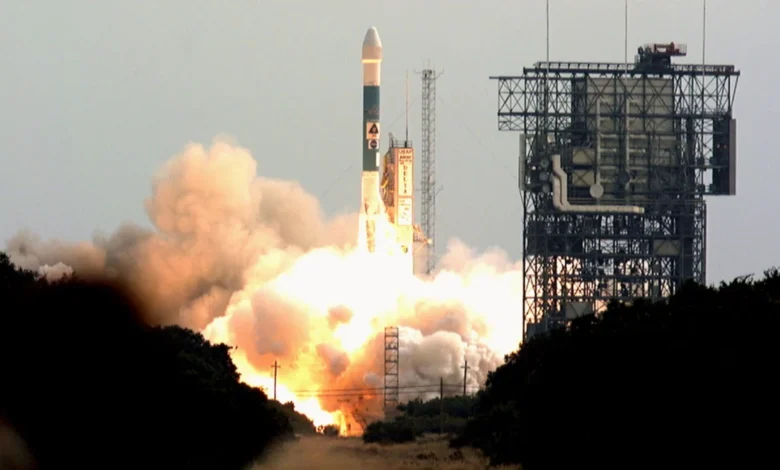
On November 7, 1996, NASA marked a monumental turning point in modern space exploration by launching the Mars Global Surveyor (MGS) spacecraft aboard a Delta II rocket from Cape Canaveral Air Force Station in Florida, decisively breaking a nearly two-decade drought of American missions to the Red Planet that had persisted since the twin Viking landers touched down in 1975.
The successful liftoff initiated an ambitious chapter of interplanetary science. Designed to operate as a high-altitude orbiter, the spacecraft was tasked with conducting a comprehensive, global reconnaissance of Mars, mapping its complex topography, analyzing its dynamic atmosphere, and probing its enigmatic interior. Over the course of its extended mission lifecycle, the Mars Global Surveyor fundamentally reshaped humanity’s understanding of the Martian environment, transitioning the scientific consensus from a view of Mars as a dry, unchanging desert to a dynamic world with a turbulent climatic past and profound evidence of historical liquid water.
A Breakthrough After a Long Hiatus
To fully appreciate the significance of the Mars Global Surveyor, one must contextualize the state of planetary science in the mid-1990s. Following the groundbreaking successes of the Viking 1 and Viking 2 missions in the late 1970s, NASA’s planetary exploration program experienced a prolonged pause due to shifting federal budgets, programmatic restructuring, and mission cancellations, most notably the Mars Observer, which heartbreakingly failed just days before entering Martian orbit in August 1993.
The failure of Mars Observer left the scientific community without orbital data for Mars for over fifteen years, creating a critical knowledge gap. Consequently, the Mars Global Surveyor was conceived as a faster, cheaper, and more focused recovery mission—often encapsulated by NASA’s "faster, better, cheaper" paradigm of the era. Built by Lockheed Martin Astronautics under the management of NASA’s Jet Propulsion Laboratory (JPL), the spacecraft utilized a streamlined payload designed to maximize scientific return while minimizing cost and complexity.
When MGS successfully entered Martian orbit on September 12, 1997, after a grueling ten-month interplanetary cruise, it did not immediately settle into its final mapping orbit. Instead, mission controllers executed an innovative and daring technique known as aerobraking. By dipping the spacecraft gently into the upper reaches of the thin Martian atmosphere over several months, engineers utilized atmospheric drag to bleed off velocity and circularize the orbit, drastically reducing the amount of heavy chemical propellant the spacecraft needed to carry at launch. Despite encountering unexpected solar panel torque issues during the harrowing aerobraking phase, the operations team successfully adapted, proving the viability of aerobraking for future deep-space missions.
Revolutionary Scientific Discoveries
Once it achieved its operational mapping orbit in March 1999, the Mars Global Surveyor began its systematic observation of the planet. Equipped with a suite of sophisticated scientific instruments—including the Mars Orbiter Camera (MOC), the Mars Orbiter Laser Altimeter (MOLA), the Thermal Emission Spectrometer (TES), and a radio science subsystem—the spacecraft amassed an unprecedented volume of data. Over its operational lifespan, MGS transmitted more data back to Earth than all previous interplanetary missions combined.
One of the most profound discoveries yielded by the mission came from the Mars Orbiter Camera, which revealed dramatic photographic evidence of gullies on steep crater and valley walls. These geological features strongly suggested that liquid water had flowed across the Martian surface in geologically recent times, sparking intense debate and renewed optimism regarding the planet’s potential to host past or present habitability.
Concurrently, the Thermal Emission Spectrometer detected widespread deposits of grey hematite, an iron oxide mineral that on Earth typically forms in aqueous environments. This pivotal finding directly influenced mission planning for subsequent surface exploration. Based on the MGS data, NASA strategically selected Meridiani Planum as the landing site for the Opportunity rover, and Gusev Crater for the Spirit rover, knowing that both locations held high probabilities of revealing water-altered mineralogy. Both rovers subsequently confirmed the presence of hematite upon arrival, validating the predictive power of orbital reconnaissance.
Furthermore, the Mars Orbiter Laser Altimeter constructed the first-ever high-resolution, three-dimensional topographic map of the entire Martian globe. MOLA’s precise laser ranging revealed the dramatic dichotomy between the heavily cratered southern highlands and the smooth northern lowlands, providing geologists with precise elevation models essential for understanding the planet’s thermal and tectonic history. MGS also monitored seasonal changes in the Martian polar caps, tracked global dust storms, and mapped the remnant magnetic field frozen into the planet’s ancient crust, indicating that Mars once possessed an active internal dynamo similar to Earth’s early magnetic shield.
A Vital Communications Relay for Surface Operations
Beyond its standalone scientific achievements, the Mars Global Surveyor played an indispensable infrastructure role in NASA’s multi-tiered exploration strategy. As NASA pivoted toward surface-based exploration with the Mars Pathfinder mission in 1997—which famously deployed the small Sojourner rover—and later with the twin Mars Exploration Rovers, Spirit and Opportunity, in 2004, the need for a reliable communication relay network became paramount.
Because rovers on the Martian surface possess limited power and low-gain antennas, transmitting high-bandwidth scientific data and imagery directly back to the Deep Space Network on Earth is exceptionally difficult. The Mars Global Surveyor bridged this critical gap. Equipped with an ultra-high-frequency (UHF) radio system, the orbiter routinely flew overhead, receiving data packets transmitted from the surface rovers and relaying them back to Earth with high fidelity.
This capability transformed MGS from a solitary observer into a cornerstone communications hub, proving that future planetary exploration would heavily rely on synergistic networks where orbiters act as data waystations for landers and rovers. The architecture pioneered by MGS established the blueprint for all subsequent Mars relay orbiters, including the Mars Odyssey, Mars Reconnaissance Orbiter, and the European Space Agency’s Mars Express.
The Unforeseen Demise and Silent Legacy
Designed for an initial primary mapping mission lasting one Martian year (approximately two Earth years), the Mars Global Surveyor proved remarkably durable, outliving its baseline specifications by nearly a decade. Its longevity was a testament to the robust engineering of the spacecraft bus and the skill of the flight operations team at JPL and Lockheed Martin.
However, the harsh environment of space eventually claimed the veteran spacecraft. In November 2006, nearly a decade after its historic launch, mission controllers noticed that MGS was failing to respond to routine commands. Subsequent analyses and orbital imagery captured by the Mars Reconnaissance Orbiter traced the anomaly back to a command sent weeks prior. During routine battery maintenance, a sequence of commands inadvertently caused one of the spacecraft’s two solar panels to articulate into a position where it was exposed to direct, unshielded sunlight for an extended period.
The resulting thermal overload caused the battery to overheat, draining its power reserves and causing the spacecraft’s computer systems to shut down. Deprived of power and unable to orient its high-gain antenna toward Earth, the Mars Global Surveyor fell permanently silent. NASA officially declared the mission concluded in January 2007, closing out one of the most prolific chapters in the history of robotic space exploration.
Institutional Reflections and Broader Implications
In the wake of its termination, space agency leaders and principal investigators heavily praised the profound impact of the Mars Global Surveyor on planetary science. NASA administrators noted that the mission effectively rewrote planetary textbooks, transforming Mars from a mysterious, blurry red dot into a complex, dynamic terrestrial world with a rich geological history.
"The Mars Global Surveyor mission overhauled scientists’ understanding of Mars by studying the entire Martian surface, atmosphere, and interior," NASA officials stated in a retrospective mission summary. "Major findings included dramatic evidence that water still flows on Mars in short bursts down hillside gullies, and the identification of water-related mineral deposits leading to selection of a Mars rover landing site for a subsequent mission."
The implications of the MGS mission extend far beyond the raw data it acquired. By validating the use of aerobraking, demonstrating the feasibility of long-duration orbital science, and establishing the operational model for orbital-surface communications relays, the mission established methodological standards that continue to govern modern planetary architecture. As space agencies globally look toward future sample-return campaigns and human missions to the Red Planet, the foundational cartographic, meteorological, and hydrological data gathered by the Mars Global Surveyor remains an invaluable cornerstone upon which future generations of explorers will build.
Related posts: