Looking Down at the Blue Planet: How a 1946 V-2 Rocket Photo Changed Humanity’s Perspective Forever

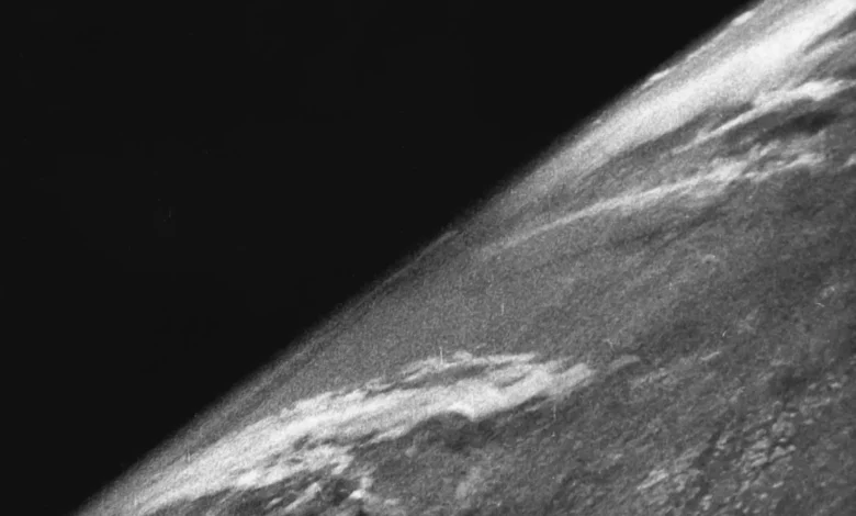
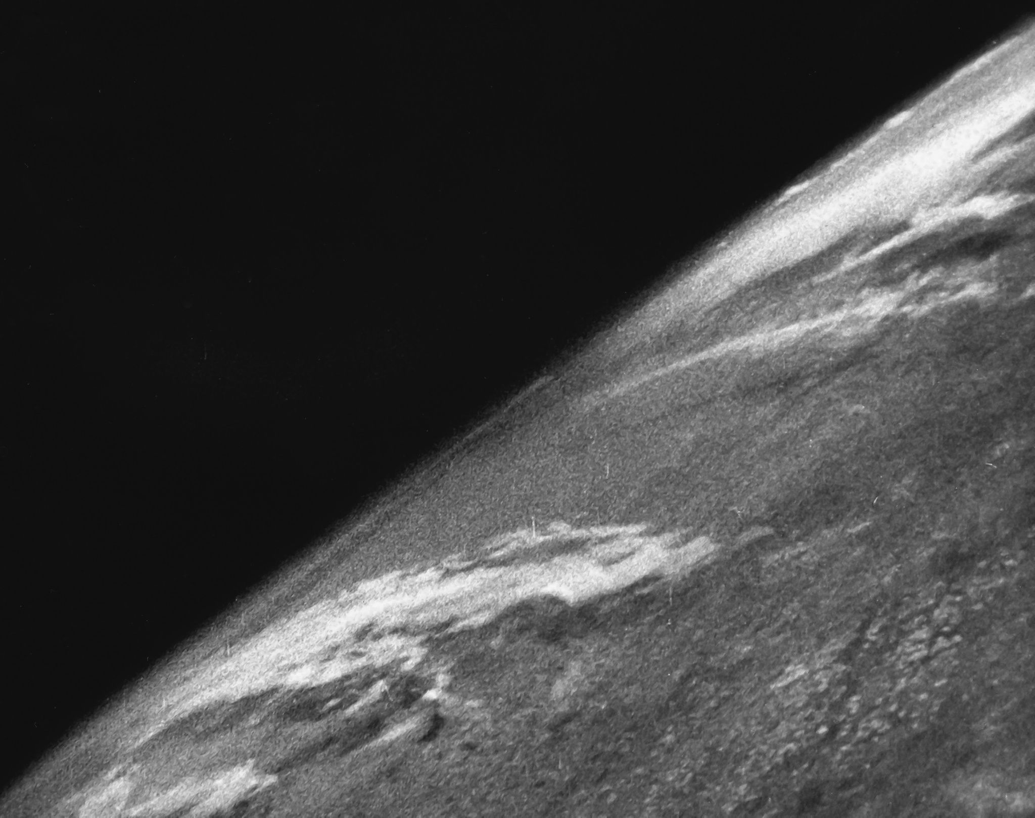
On October 24, 1946, a modified German V-2 ballistic rocket launched from the White Sands Missile Range in New Mexico, piercing the upper atmosphere and carrying a 35-millimeter motion picture camera that would forever alter how humanity viewed its place in the cosmos. At an altitude of approximately 65 miles—well above the stratosphere and past the internationally recognized boundary of space known as the Kármán line—the camera snapped a grainy, black-and-white frame of the curvature of the Earth set against the absolute blackness of space. Though primitive by modern digital standards, these images represented a monumental technological and psychological milestone: the first time human beings laid eyes on their home planet from the vantage point of the cosmos.
The historical significance of this event extends far beyond a simple photographic novelty. It marked the practical dawn of space-based Earth observation, laying the groundwork for modern meteorology, global reconnaissance, commercial satellite networks, and environmental science. Before this mission, humanity had only ever looked up at the stars or horizontally across horizons; on that crisp autumn day in New Mexico, the lens was turned inward, initiating an era where the Earth could be studied as a singular, interconnected system from above.
The Technical Feat: Engineering at the Edge of Space
The achievement was made possible by a team of scientists, engineers, and military personnel working under Operation Hermes, a post-World War II U.S. Army program that repurposed captured German V-2 rockets. Testing these advanced propulsion systems required vast expanses of uninhabited land, making the White Sands Proving Ground an ideal facility for experimental rocketry.
Mounted inside the nose cone of the missile was a robust 35-millimeter motion picture camera enclosed in a specially engineered steel housing designed to protect the delicate film stock from the extreme conditions of atmospheric re-entry. As the V-2 soared upward, the camera faithfully captured a new frame every second and a half. The rocket reached its peak altitude of roughly 105 kilometers before beginning a catastrophic, uncontrolled descent back toward the floor of the New Mexico desert.
Upon impact, the V-2 and its onboard equipment struck the terrestrial surface at a staggering velocity of approximately 340 miles per hour, completely obliterating the launch vehicle and the camera body. However, the protective steel cassette housing the film performed precisely as engineers intended. The physical medium survived the high-speed crash, though it was scattered among the twisted metal wreckage of the missile.
The Recovery and Immediate Reaction
Following the launch, recovery teams dispatched from the missile range tracked the debris field to locate the vital film canister. When scientists retrieved the mangled steel case and developed the film in a laboratory, the resulting frames revealed a perspective no living human had ever witnessed. The images showed the sunlit curve of the planet blanketed by cloud formations, with the vast, dark void of space looming above.
Accounts from the era note that when the researchers first laid eyes on the developed negatives, they were overcome with excitement, celebrating an achievement that bridged aeronautical engineering and planetary science. The realization that they now possessed photographic evidence of the Earth from the threshold of space electrified the scientific community, instantly shifting theoretical discussions about space exploration into tangible reality.
Chronology of Early Space Observation
To understand the trajectory of Earth observation, it is helpful to place the 1946 V-2 flight within a broader historical timeline of early space-faring milestones:
- March 1946: Researchers begin outfitting V-2 rockets at White Sands with scientific instruments, cosmic ray detectors, and cameras.
- October 24, 1946: A V-2 rocket flight captures the first-ever photograph of Earth from an altitude of 65 miles.
- 1947–1950s: Subsequent V-2 flights progressively capture wider swaths of the continent, demonstrating the utility of high-altitude photography for weather patterns and geography.
- October 4, 1957: The Soviet Union launches Sputnik 1, the first artificial satellite, officially initiating the Space Age.
- April 12, 1961: Soviet cosmonaut Yuri Gagarin becomes the first human in space, visually confirming the majestic view of the Earth’s blue sphere.
- December 1968: Apollo 8 astronauts capture the iconic "Earthrise" photograph, further cementing the visual fragility of the planet in the global consciousness.
Strategic and Meteorological Implications
In the immediate aftermath of the 1946 flight, military and intelligence analysts quickly recognized the immense strategic value of space-based optics. Traditional aerial reconnaissance was limited by the altitude ceilings of propeller and early jet aircraft, as well as geopolitical boundaries. A camera operating from the edge of space or from orbital trajectories could survey vast swaths of territory without immediate risk of interception. This capability served as the technological precursor to modern reconnaissance and spy satellite programs developed during the Cold War.

Simultaneously, civilian and scientific sectors identified profound applications for meteorology and agriculture. Weather forecasting, which had historically relied on localized barometric readings and sparse maritime reports, stood to gain immeasurably from continuous, macro-scale imaging of cloud cover and atmospheric systems. Over the subsequent decades, the ability to monitor weather fronts, track tropical cyclones, and map agricultural yields from orbit transformed meteorology into a precision science. Today, Earth observation is among the most heavily utilized commercial and governmental sectors in the space industry, deploying fleets of specialized satellites to monitor climate change, deforestation, ocean currents, and urban expansion.
Cultural and Environmental Shifts
Beyond its technical and military utility, the advent of Earth photography catalyzed a profound psychological shift in humanity’s self-perception. Before the mid-20th century, the Earth was largely viewed as an infinite resource with boundless frontiers. Seeing the planet as a finite, brightly colored sphere isolated within an unforgiving and boundless void altered this philosophical paradigm.
Historians and sociologists frequently credit these early space photographs—and the more polished color images that followed during the Apollo program—as catalysts for the modern environmental movement. The visual isolation of the planet emphasized its ecological fragility. The realization that the atmosphere, oceans, and landmasses constituted a closed, self-contained life support system encouraged international cooperation on environmental protections, resource management, and conservation treaties.
Conclusion and Legacy
The grainy black-and-white snapshot captured by a modified military rocket over the New Mexico desert on October 24, 1946, stands as a watershed moment in human history. What began as an experimental test of captured wartime technology inadvertently opened a new visual dimension for mankind. By looking down at the Earth from the threshold of space for the very first time, scientists did not merely capture a geographical image; they provided the species with a mirror, reflecting both the beauty and the vulnerability of our shared home in the universe.
Related posts: