The Geological Divide of the Maine Coastline How Glacial History and Bedrock Define the Pine Tree States Diverse Shorelines

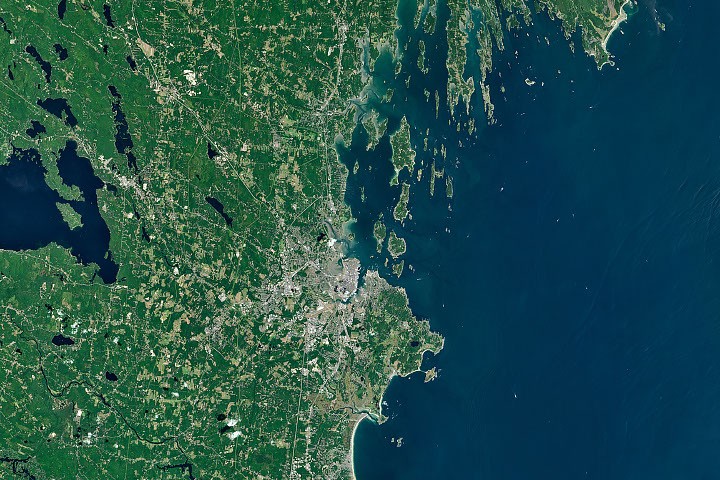
The coastline of Maine is often characterized by its rugged beauty, yet a closer inspection reveals a profound geological schism that separates the state’s southern reaches from its jagged midsection and northern expanses. To the west and south of Portland, the landscape is dominated by expansive sandy beaches and sprawling salt marshes. To the northeast, the terrain transforms into a "tortured" landscape of narrow peninsulas, deep-water inlets, and rocky archipelagoes. This dramatic shift, captured in high-resolution Landsat imagery, is the result of millions of years of tectonic activity, the crushing weight of mile-thick ice sheets, and the relentless flow of sediment-laden rivers.
The Cultural Context: Wabanaki Creation and the Spirit of Glooscap
Long before modern geologists mapped the bedrock of the Gulf of Maine, the Indigenous Wabanaki people—the "People of the Dawnland"—developed a rich oral tradition to explain the unique features of their ancestral home. These stories often center on Glooscap, a benevolent transformer and cultural hero. According to legend, Glooscap’s movements through the Bay of Fundy and along the Downeast coast shaped the very earth.
In one prominent myth, Glooscap pursued a giant beaver that had dammed the Saint John River. During the struggle, Glooscap threw massive clods of earth and stone, which became the islands of Casco Bay and the boulders that litter the coast of Acadia. His "stone canoe," scraping against the seafloor, is said to have carved the deep channels and rocky ridges that define the Midcoast region. While these myths provide a spiritual and cultural framework for the land, they also reflect a keen observation of the physical environment—noting the presence of "erratics," or large boulders left in unusual places, which science would later identify as the work of retreating glaciers.
A Chronology of Change: The Last Glacial Maximum and the DeGeer Sea
The scientific narrative of Maine’s coastline begins approximately 20,000 years ago during the Last Glacial Maximum. At this time, the Laurentide Ice Sheet covered nearly all of New England, extending far out onto the continental shelf. The sheer weight of the ice, which was over a mile thick in some areas, depressed the Earth’s crust, pushing the land downward.
As the climate warmed and the ice began to retreat roughly 14,000 to 12,000 years ago, a complex geological dance occurred. Because the land had been depressed by the ice, the rising sea levels from the melting glaciers flooded the interior of Maine, creating what geologists call the DeGeer Sea. During this period, the coastline was located dozens of miles inland from its current position.
As the weight of the ice vanished, the land began to "rebound" in a process known as isostatic adjustment. This rising of the crust, combined with fluctuating sea levels, eventually stabilized into the shoreline we recognize today. However, the legacy of the ice remained in the form of "glacial till"—a mixture of clay, sand, and boulders—and the scoured valleys that would become the state’s famous fjords and bays.
Southern Maine: The Legacy of the White Mountains and the Saco River
The transition point for Maine’s coastal morphology occurs near Portland. To the south, the coastline is characterized by "arcuate" or embayed beaches, such as those found in Saco Bay. This region is home to Maine’s longest contiguous sandy beach and the Scarborough Marsh, the state’s largest saltmarsh.
The presence of these sandy features is not accidental. According to Peter Slovinsky, a geologist with the Maine Geological Survey, the sediment that builds these beaches has a distinct mountain-to-sea pedigree. Much of the sand is sourced from the weathering and breakdown of the granite peaks of the White Mountains in New Hampshire. Over millennia, the Saco River has acted as a conveyor belt, transporting fine-grained quartz and feldspar sediment from the mountains to the Atlantic.
Once this sediment reaches the coast, the relatively shallow shelf and the energy of the waves rework the material. The waves distribute the sand into smooth, curving arcs between rocky headlands. These headlands, often composed of erosion-resistant granite, act as "anchors" for the sandy beaches. The result is a coastline that is softer, more uniform, and highly conducive to the tourism-driven economies of towns like Old Orchard Beach, Kennebunkport, and Ogunquit.
The Midcoast: A Drowned Landscape of Metamorphic Ridges
East of Portland, the geological story takes a more complex turn. Here, the underlying bedrock is primarily metamorphic—rock that has been folded, twisted, and recrystallized under intense heat and pressure during ancient mountain-building events. These rocks, including schist and gneiss, form long, parallel ridges and valleys that run roughly north-south.
During the last ice age, the glaciers exploited the existing weaknesses in these metamorphic layers. As the ice moved southward, it scoured out the softer valleys while leaving the harder ridges intact. When the sea level rose following the glacial retreat, it flooded these scoured valleys, creating a "drowned" coastline of long, narrow peninsulas (necks) and deep, protected harbors.

Nicholas Whiteman, a geologist with the Maine Geological Survey, describes the Casco Bay region as a "tortured" landscape. The orientation of the islands and peninsulas follows the structural grain of the metamorphic bedrock. This creates a jagged, highly indented shoreline where the distance "as the crow flies" may be only a few miles, but the actual shoreline distance can be hundreds of miles long. This unique topography provides the deep-water access that historically made Maine a center for shipbuilding and international trade.
Economic Implications: Lobsters, Oysters, and the Working Waterfront
The geological divide between the sandy south and the rocky Midcoast does more than dictate the scenery; it serves as the foundation for Maine’s multi-billion-dollar maritime economy.
The rocky, protected inlets of the Midcoast and Downeast regions provide the ideal habitat for the American lobster (Homarus americanus). Lobsters require rocky crevices for protection from predators, and the cold, nutrient-rich waters that circulate through the deep channels of Casco and Muscongus Bays support massive populations. Consequently, communities like Harpswell and Stonington consistently lead the state in lobster landings. The jagged coastline provides thousands of miles of "edge habitat," which is far more productive for shellfishing than the straight, sandy shores of the south.
In recent years, the geological features of the Midcoast have also fueled a burgeoning aquaculture industry. The Damariscotta Estuary and Casco Bay have become the epicenter of Maine’s oyster farming. The "merroir" of an oyster—its unique flavor profile—is determined by the specific microclimate of the water in which it grows.
Tom Kiffney, a researcher at the University of Maine, notes that the sheltered nature of these rocky estuaries protects oyster gear from heavy surf while allowing for a diverse range of salinities and temperatures. "The complex shoreline creates numerous pockets where water quality and temperature vary significantly over short distances," Kiffney explained. This allows farmers to produce oysters with distinct tastes, ranging from briny and metallic to sweet and buttery.
Modern Monitoring: Landsat and the Future of Coastal Management
As climate change accelerates, understanding the geological foundation of the coast has become a matter of economic survival. Rising sea levels and increased storm intensity affect the sandy south and the rocky Midcoast in different ways. The sandy beaches of Saco Bay are highly susceptible to erosion and "marsh migration," where salt marshes attempt to move inland as waters rise.
In contrast, the rocky peninsulas of the Midcoast are more stable but face challenges related to warming water temperatures. Researchers are now using Landsat satellite data to monitor these changes in real-time. By analyzing sea surface temperatures and turbidity (water clarity), scientists can predict where lobster populations might migrate or where the next ideal site for an oyster farm might be.
The Landsat program, a joint effort between NASA and the U.S. Geological Survey, provides a decades-long record of coastal change. This data allows geologists to see how sediment is moving, how vegetation is shifting in the salt marshes, and how human development is encroaching on these fragile systems.
Conclusion: A Landscape Defined by Contrast
The coastline of Maine remains one of the most geologically diverse regions in North America. From the Glooscap legends of the Wabanaki to the satellite-derived maps of modern researchers, the fascination with this "divided" shore continues. The transition at Portland represents a boundary between two different worlds: one shaped by the gentle accumulation of mountain sands and the other forged in the metamorphic fires of the Earth’s crust and carved by the relentless power of ice.
As Maine moves forward into an era of environmental uncertainty, the bedrock and sediment that define its shores will continue to dictate the state’s destiny. Whether through the lens of a tourist on a sandy beach or a sternman on a lobster boat in a rocky cove, the geological legacy of the Last Glacial Maximum remains the silent architect of the Maine experience.
Related posts: