Rapid Rise of Navajo Reservoir Highlights Extreme Hydrological Shifts in the U.S. Southwest

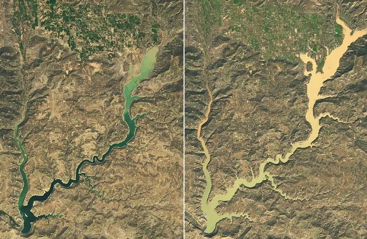
The U.S. Southwest, a region historically defined by its arid climate and chronic water scarcity, experienced a dramatic hydrological reversal in the autumn of 2026. A series of intense, back-to-back atmospheric moisture events flooded the Four Corners region, transforming the landscape and providing a sudden, albeit destructive, reprieve from long-term drought conditions. The most striking visual evidence of this transition is the Navajo Reservoir, which underwent a profound transformation between late September and early November, rising nearly 60 feet (18 meters) and reaching water levels not seen in over seven years.
A Chronology of the Deluge
The transformation began in late October 2026, following a period where the region had been reeling from the lingering effects of a 2025–2026 "snow drought." Because the previous winter failed to deliver a robust snowpack, the typical spring runoff—which usually bolsters the reservoir—was virtually nonexistent. By September 20, 2026, the Navajo Reservoir sat at a precarious 60 percent of its average capacity.
The atmosphere, however, shifted gears in mid-autumn. Starting in late October, a series of low-pressure systems, influenced by an active El Niño pattern, began to funnel significant moisture into the high-elevation regions of northern New Mexico and southern Colorado. The intensity of these storms was anomalous for the season. Between October 21 and October 23, the region absorbed massive precipitation totals; the town of Pagosa Springs, Colorado, recorded 5.05 inches of rainfall, an extraordinary amount for a high-desert environment.
By October 23, the San Juan River had reached major flood stage. As the ground became saturated and unable to absorb further moisture, the runoff surged into the river channels, eventually feeding the Navajo Reservoir. A second, equally powerful pulse of rain arrived on November 1, pushing the San Juan River to within inches of a record set during a historic 1911 flood event. This rapid influx of water caused the reservoir to climb to 108 percent of its average capacity by November 7—a staggering recovery from the 60 percent mark recorded just seven weeks prior.
Satellite and Ground-Level Analysis
The rapid filling of the reservoir was documented extensively by the Operational Land Imager (OLI) aboard the Landsat 9 satellite. Comparative imagery acquired on September 20 and November 7 reveals a reservoir that has visibly expanded, drowning previously exposed shorelines and encroaching on land that had been arid for years.
While satellite data provides the macro-level view, ground-level data from the U.S. Army Corps of Engineers confirms the severity of the surge. The water levels in the reservoir, which serves as a critical water storage hub for the region, reached their highest point since August 2019. This is particularly significant given that the Bureau of Reclamation had been actively managing the reservoir by decreasing releases as early as mid-September, a defensive measure that ultimately could not contain the sheer volume of water generated by the unprecedented autumn rain.
Regional Impacts and Emergency Responses
The flooding was not merely a matter of replenished water supply; it was a significant emergency management crisis. In Pagosa Springs, the rapid rise of the San Juan River necessitated immediate, life-saving measures. Local emergency services were forced to issue urgent evacuation orders as streets were inundated and residential property sustained significant water damage.
Responders conducted dozens of rescues in the affected areas, underscoring the dangers inherent in sudden hydrological shifts. The flooding extended beyond the San Juan basin, impacting wide swaths of southeast Utah, northern Arizona, and northwest New Mexico. Throughout these areas, precipitation totals from early September to early November were recorded at two to four times the historical average, marking a distinct departure from the dry conditions that have characterized the Southwest for decades.
Climate Context and the El Niño Connection
Meteorologists and climatologists have pointed to the current El Niño event as a primary driver of this extreme weather. El Niño is characterized by warmer-than-average sea surface temperatures in the equatorial Pacific, which strengthens the jet stream and shifts its trajectory. During an active El Niño, the jet stream often dips further south, steering moisture-laden, low-pressure systems directly into the interior of the American Southwest.
In the case of the 2026 autumn storms, the low-pressure system was exceptionally low in latitude. By drawing energy from the unusually high ocean temperatures, these systems carried a higher moisture content than typical seasonal storms. While this provided the much-needed "drought-busting" precipitation, the concentration of this water in a short period rendered the landscape vulnerable to flash flooding, as the parched, compacted soil of the drought-stricken region could not accommodate such high infiltration rates.
Long-Term Implications for Water Management
The U.S. Drought Monitor’s November 3 summary confirmed a significant milestone: short-term drought conditions have effectively ended for much of the Southwest and the Great Basin. For water managers, this presents a complex scenario. While the immediate replenishment of reservoirs like Navajo is a net positive for agricultural and municipal water security, the events of 2026 demonstrate the volatility of the region’s water future.
The transition from a "snow drought" in early 2026 to extreme, rain-driven flooding in late 2026 illustrates the "whiplash" effect increasingly associated with a warming climate. In this scenario, the traditional reliance on predictable spring snowmelt is challenged by more frequent, erratic, and intense precipitation events.
"We are moving into an era where the old models of water management are being tested by extreme variability," noted one hydrological analyst. The capacity of regional infrastructure—dams, levees, and drainage systems—to handle these rapid, high-volume inflows is now a critical area of focus for the U.S. Army Corps of Engineers and the Bureau of Reclamation.
Future Outlook and Resilience
While the current relief is welcome, officials warn against complacency. Long-term drought markers persist in various parts of the Southwest, as ground-water tables and deep-soil moisture levels take longer to recover than surface-level reservoirs. Furthermore, the damage caused by the October and November floods serves as a reminder that the region’s geography is ill-equipped for massive, fast-moving water events.
Moving forward, the focus is expected to shift toward enhanced floodplain mapping and the reinforcement of infrastructure in flood-prone zones like the San Juan River valley. The 2026 events have provided a comprehensive data set that will likely influence how municipalities and federal agencies approach urban planning and water storage in the coming years.
As the Four Corners region begins the recovery process, the images of a full Navajo Reservoir stand as a testament to the power of a single, highly active weather season. The region has effectively bypassed a year of drought in a matter of weeks, proving that while the Southwest may be defined by its dryness, its hydrological future will be increasingly defined by the extremes of the sky.