Estimation and cause of the seasonal oscillation between Earth’s centre of mass and centre of figure

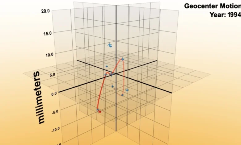
The question of where exactly Earth’s center of mass resides—the "geocenter"—is often dismissed as a trivial inquiry with an obvious answer: the geometric middle of the planet. However, for the global geodetic community, this point is the fundamental anchor for all coordinate systems, satellite navigation, and environmental monitoring. Recent research published in the Geophysical Journal International has pushed the boundaries of this measurement, achieving a precision of less than one millimeter. This breakthrough, led by Donald F. Argus and his colleagues, provides a high-resolution window into the dynamic redistribution of mass across our planet, fundamentally altering our understanding of how Earth’s atmosphere, oceans, and solid crust interact on a seasonal and geological scale.
The Evolution of Geodetic Precision
To comprehend the significance of this milestone, one must understand the evolution of geodetic measurement. Earth’s center of mass is the point around which the planet’s total mass is balanced. Because the Earth is not a rigid, unchanging sphere, this point is in constant motion. For decades, scientists have relied on space-based geodesy to track this elusive coordinate.
The journey toward millimeter-level precision began in the late 20th century. During the 1980s and 1990s, the Laser Geodynamics Satellites (LAGEOS) were the gold standard. These dense, spherical satellites were equipped with laser retroreflectors, allowing ground-based stations to bounce laser pulses off them to determine their precise altitude and orbital path. Since satellites orbit the center of mass, any fluctuation in their trajectory indicates a corresponding shift in the Earth’s gravitational center. Through these efforts, researchers managed to pin down the geocenter to within approximately one centimeter—a remarkable feat for the time, but insufficient for the modern requirements of climate science and global navigation.
Methodology: Integrating GPS and Low-Earth Orbit Data
The study by Argus et al. represents a paradigm shift by integrating modern data streams that were unavailable to earlier geodetic researchers. The methodology relies on two primary advancements. First, the team incorporated high-precision GPS data from a global network of ground-based observatories. This allowed the researchers to correct for the "noise" created by the movement of the Earth’s crust beneath the observatories themselves—a process known as crustal loading.
Second, the team synthesized data from a constellation of Low-Earth Orbit (LEO) satellites. By analyzing the orbital dynamics of these satellites in conjunction with the established LAGEOS data, the researchers were able to filter out atmospheric drag and other non-gravitational perturbations. This multi-layered data integration reduced the margin of error from the previous centimeter-level threshold to sub-millimeter precision. By essentially "de-noising" the Earth’s surface movements, the researchers isolated the actual migration of the geocenter relative to the planet’s geometric center.
Seasonal Dynamics and the Amazonian Influence
The primary focus of the study was to analyze the seasonal oscillation of the geocenter. The Earth is a dynamic system where mass is constantly being redistributed. During the Northern Hemisphere’s winter, significant volumes of water are sequestered in the form of snow and ice in the Arctic and high-latitude regions. Simultaneously, the movement of ocean currents and the shifting of air masses create a constant "sloshing" effect.
Historically, models suggested that the seasonal movement of water—specifically the heavy rainfall cycles in the Amazon basin and the resulting drainage into the delta—contributed significantly to the oscillation of the geocenter. However, the data from this study yielded a surprising result: the seasonal drift is roughly half of what previous models had estimated.
This finding suggests that the coupling between the Earth’s hemispheres is less direct than previously hypothesized. It implies that the total mass of water and air moving across the equator is constrained by complex feedback loops that mitigate the expected displacement of the geocenter. Scientists now theorize that the solid Earth’s elastic response to these mass shifts may partially offset the gravitational pull, keeping the geocenter closer to the center of figure than once feared.
Long-Term Geological Implications
While seasonal shifts represent the periodic heartbeat of the Earth, the study also highlights longer-term, non-periodic movements. Significant tectonic events, such as major earthquakes and volcanic eruptions, cause localized mass displacement that can result in permanent, albeit minute, shifts in the geocenter.
These geological shifts have profound implications for Earth’s rotation. The principle of conservation of angular momentum dictates that if mass moves closer to the axis of rotation, the planet’s rotation speed must increase. Conversely, if mass moves further away, the planet slows down. By measuring these shifts with such extreme precision, researchers can now quantify how geological events influence the length of a day, providing a clearer picture of the interconnectedness of Earth’s interior and its exterior atmospheric shell.
Official Perspectives and Scientific Impact
The implications of this research extend far beyond academic curiosity. In a statement regarding the findings, independent researchers in the field of space geodesy have noted that this data is critical for the maintenance of the International Terrestrial Reference Frame (ITRF). The ITRF is the system that defines the coordinates of points on Earth’s surface, and it is the backbone of the Global Navigation Satellite System (GNSS).
"Without a precise geocenter, our ability to calculate global sea-level rise, monitor ice-sheet melting, and ensure the safety of satellite constellations is compromised," noted one geophysicist familiar with the study. The ability to measure these shifts within a millimeter allows for the calibration of satellite altimetry, which is vital for monitoring climate change. If we cannot distinguish between a shift in the satellite’s orbit and a rise in sea level, our climate models could be fundamentally flawed. This study provides the corrective factor needed to refine those models.
Practical Applications: Shipping, Transport, and Navigation
For the general public, the impact of these findings is often realized through technology. Modern transportation, autonomous shipping, and global logistics depend entirely on sub-centimeter positioning accuracy. Satellite constellations, such as GPS, Galileo, and GLONASS, rely on a static center of mass to broadcast accurate timing and location signals.
As these constellations age and as our reliance on automated navigation increases, the precision of the underlying geodetic model becomes paramount. A shift in the geocenter that is not properly accounted for could lead to cumulative errors in navigation. Furthermore, the precision achieved in this study allows for better modeling of satellite orbital decay. As more commercial entities launch satellite fleets into low-Earth orbit, the need to predict their trajectories with extreme accuracy—to avoid orbital collisions—has become an economic and safety imperative.
Future Directions: A New Era of Geodesy
The work of Argus et al. serves as a foundational text for the next generation of geodetic research. By proving that sub-millimeter measurements are possible, the study encourages further investment in ground-based laser tracking stations and the deployment of advanced satellite sensors.
Looking forward, the scientific community is expected to focus on the "noise" reduction techniques established here to investigate the relationship between the Earth’s deep interior and surface phenomena. There is growing interest in whether the core-mantle boundary interactions can be detected through these minute geocenter oscillations. As we continue to refine our measurements, we are effectively transforming the entire planet into a giant laboratory.
Conclusion
The realization that we can now pinpoint the center of our planet with the precision of a grain of sand is a testament to the advancements in modern science. By looking outward at the orbits of satellites, we have gained an intimate understanding of the shifting weight of our own world. The study published in the Geophysical Journal International is not merely an exercise in high-precision mathematics; it is a vital tool for navigating a changing planet. As Earth’s climate continues to evolve and as our technological dependence on precise positioning grows, the ability to account for every millimeter of movement will remain a cornerstone of global stability and scientific progress. The center of the Earth may be hidden beneath thousands of miles of rock, but through the lens of satellite geodesy, it is no longer beyond our reach.