U.S. Experiences Hottest and One of the Driest Summers on Record in 2026, NOAA Confirms

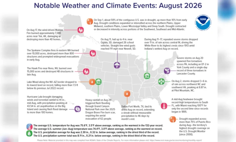
The summer of 2026 has officially etched its name into the climate history books, shattering temperature thresholds and intensifying environmental strains across the contiguous United States. According to a comprehensive data report released by the National Oceanic and Atmospheric Administration (NOAA), the June-through-August period was the hottest summer experienced across the nation in at least 132 years of modern record-keeping.
The unprecedented season bypassed previous historic highs by a wide margin, pushing average nationwide temperatures to a staggering 3 degrees Fahrenheit (1.67 degrees Celsius) above the twentieth-century norm. This drastically eclipses the prior modern record set in 2021, when summer temperatures hovered 0.4 degrees Fahrenheit (0.22 degrees Celsius) above average. Compounding the scorching conditions, the meteorological season was also characterized by severe precipitation deficits, placing more than half of the country under siege by expanding drought conditions by the time September arrived.
A Chronology of Extremes: Tracing the 2026 Summer Season
The journey toward this record-breaking summer began with an unusually warm transition from spring into early June. As high-pressure systems, colloquially termed heat domes, anchored themselves over vast stretches of the North American continent, heatwaves manifested earlier and persisted longer than historical averages indicated.
By mid-summer, the intensity of the atmospheric trapping mechanisms became glaringly apparent. While the contiguous United States baked under unrelenting sunshine, regional anomalies began compounding the issue. June set preliminary warnings with steady climbs in daily minimum temperatures, meaning nighttime cooling offered little respite to urban and rural populations alike.
July sustained the pressure, setting regional records in the Pacific Northwest and the Great Plains. However, the climatic pinnacle—or nadir, depending on the perspective of public safety officials—occurred in August. NOAA data highlights that August 2026 was the hottest single August in the 132-year observational record, maintaining an average temperature across the contiguous U.S. that reached 75.6 degrees Fahrenheit (24.2 degrees Celsius)—a remarkable 3.5 degrees Fahrenheit (1.94 degrees Celsius) above the long-term monthly mean.
Deep Dive Into Regional Impacts and Meteorological Data
While the entire contiguous United States felt the thermal burden, the distribution of heat and dryness was geographically skewed toward the southern and western tiers. The American Southwest, the southern Rockies, the southwestern Plains, southern Florida, California, Nevada, New Mexico, and Colorado experienced the most acute anomalies. In these regions, daily maximum temperatures frequently breached historical ceilings, straining local energy grids and accelerating water evaporation rates.
Simultaneously, the hydrological balance of the nation experienced a severe disruption. Total precipitation across the contiguous U.S. fell 0.32 inches (0.8 centimeters) below the historical average. This deficit was sufficient to classify the summer of 2026 as the third-driest summer on record and the driest since the turn of the millennium in 2000.
By September 1, staggering statistics emerged from NOAA’s drought monitoring assessments: approximately 59.1% of the contiguous United States was suffering under varying classifications of drought. The agricultural heartland, the upper Midwest, the Deep South, and extensive portions of the West bore the brunt of these moisture shortages. The crisis extended beyond the mainland; over 75% of Puerto Rico found itself grappling with drought conditions, with an alarming 40% categorized as experiencing "extreme drought."
A Snapshot of August Disasters: Fire, Wind, and Floods
The compounding effects of extreme heat and dryness culminated in a volatile mix of natural disasters during the final month of the meteorological summer. August 2026 served as a case study in meteorological extremes, showcasing how climate volatility manifests in diverse ways simultaneously.
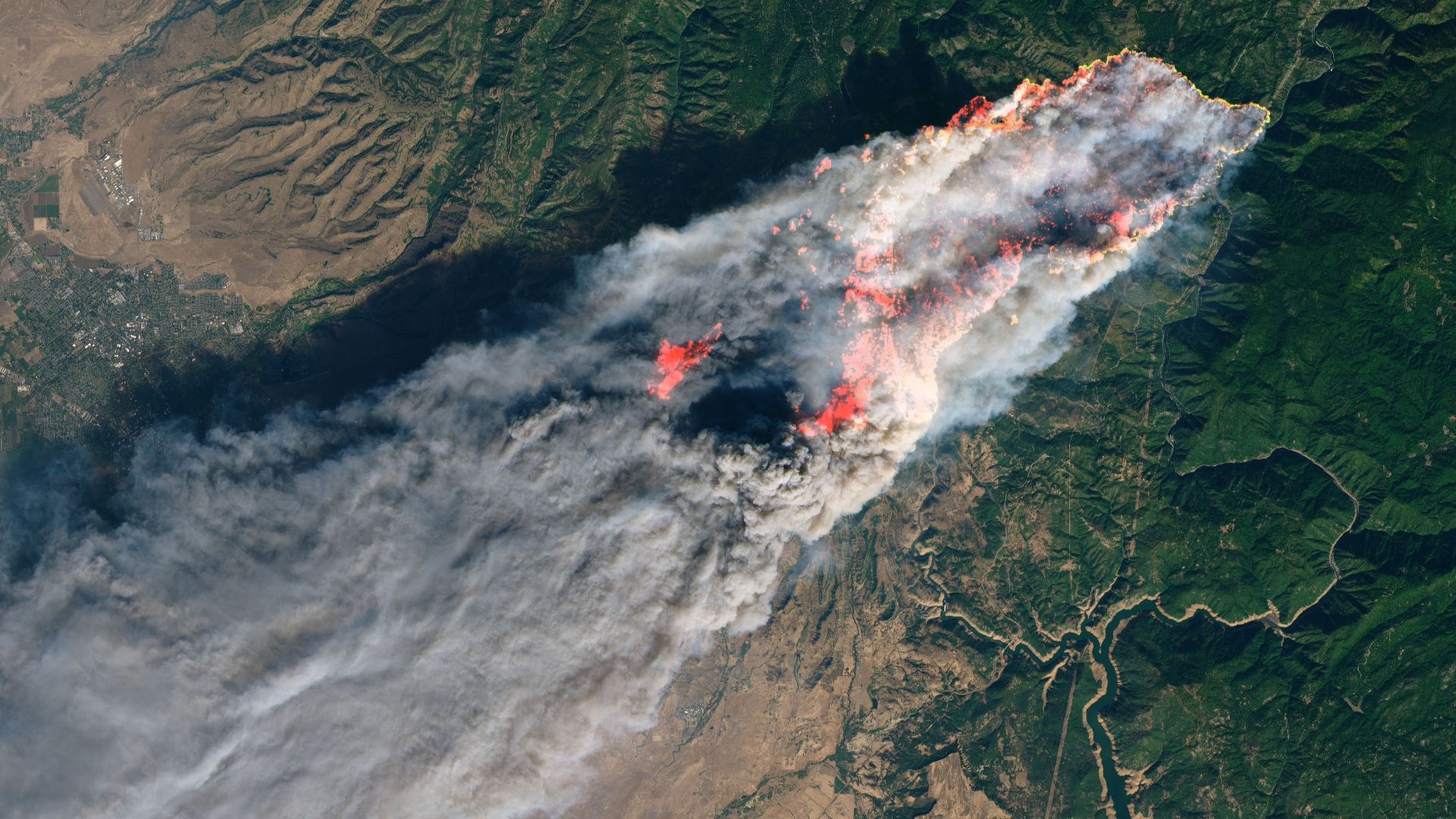
In the Pacific Northwest, fires aggressively consumed more than 10,000 acres in eastern Washington before jumping state lines into Oregon. Concurrently, fast-moving wildfires ignited across parched landscapes in Nevada and interior Alaska. High-wind events further complicated disaster management; South Dakota witnessed destructive wind gusts reaching up to 111 miles per hour (178.6 kilometers per hour), uprooting infrastructure and downing power lines.
Conversely, the same atmospheric instability that starved parts of the country of rain delivered destructive moisture elsewhere. Southern Florida endured oppressive, humid heatwaves punctuated by severe localized storms, while tropical activity threatened island territories. Hurricane Lala brought torrential rainfall, hurricane-force winds, and significant flooding to Hawaii, demonstrating the dual threat of simultaneous droughts and severe precipitation events across different domestic geographies.
Broader Implications and Long-Term Context
The accumulation of these extreme weather events aligns with broader, established scientific consensus regarding anthropogenic climate change. Climatologists emphasize that rising global temperatures—driven primarily by greenhouse gas emissions from fossil fuel combustion, industrial manufacturing, and intensive land-use changes—fundamentally alter atmospheric circulation patterns.
As the atmosphere warms, its capacity to hold moisture increases, leading to a "hydro-climate whiplash" effect. Regions prone to dryness experience accelerated evaporation that bakes soils and triggers flash droughts, while storm systems sweeping across other areas unleash torrential, concentrated precipitation. This dynamic directly elevates the baseline risk for catastrophic wildfires, agricultural failures, and structural damage from severe storms.
Furthermore, the cryosphere and marine environments continue to register parallel alarms. Recent satellite observations from polar research programs highlight accelerated glacial and floating ice loss in regions like Greenland, contributing to progressive sea-level rise that threatens coastal communities worldwide.
Outlook and Mitigation Challenges
As the meteorological transition shifts from summer to autumn, federal and state agencies face daunting recovery and mitigation tasks. NOAA’s seasonal outlook indicates that a significant portion of the current drought conditions will persist into the fall months, leaving soils depleted and vegetation dangerously dry heading into the traditional wildfire seasons of the autumn and winter.
Emergency management agencies and policy experts are increasingly calling for enhanced infrastructure resilience, updated water management frameworks, and aggressive carbon-reduction strategies. Without systemic adaptations to a rapidly warming climate, scientists warn that historic anomalies like the summer of 2026 will transition from statistical outliers to the expected baseline of the American climate reality.
Related posts: